
Windy weather: how we can determine it better

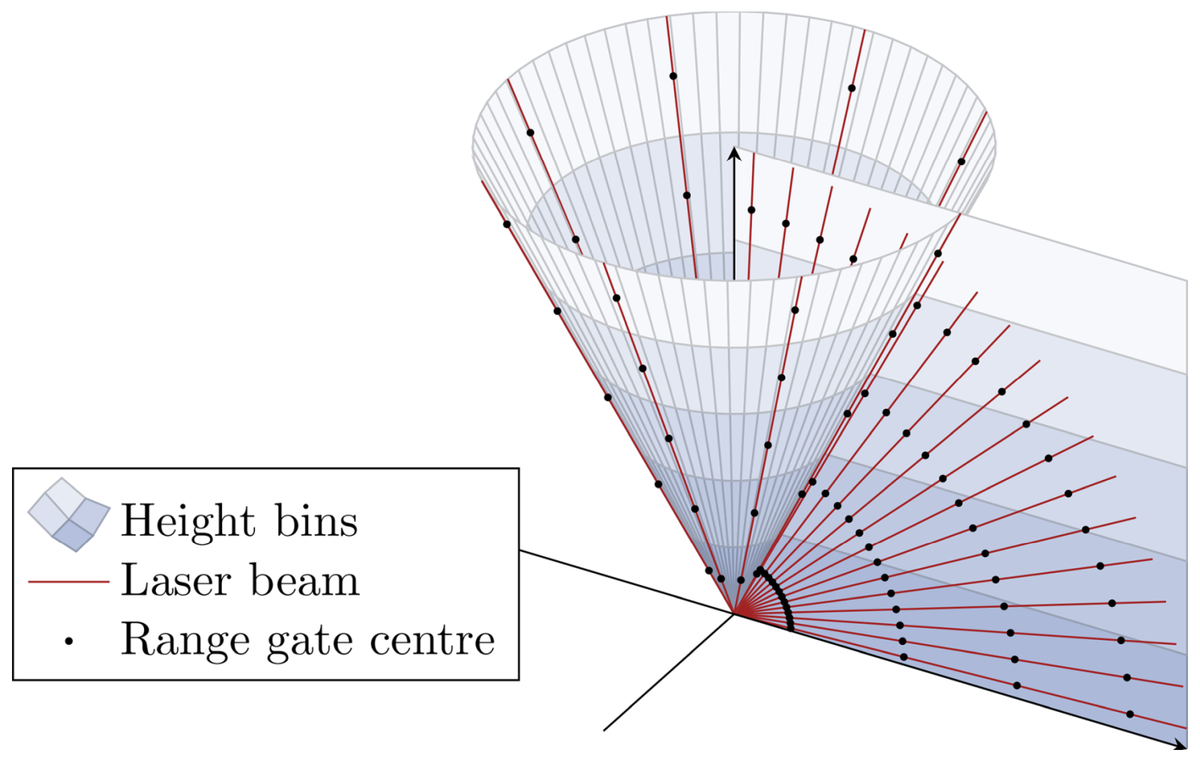

Wind is key in meteorology and weather forecasting. Wind measurements close to the surface with so-called anemometers, mounted at meteorological towers, are easy to implement and well-known to the public. In contrast, measurements of wind at higher altitudes require complex laser instruments, so-called Doppler lidars. IMKTRO operates up to ten Doppler lidars within the Integrated Atmospheric Observation System KITcube. These laser instruments emit infrared laser light and receive the light scattered back by aerosols. Subsequently, the wind can be determined by analysing the Doppler shift of the backscattered infrared light. The movement of the aerosols induces a slight colour shift of the light, which is analysed with high precision. However, this measurement provides only the wind velocity in the direction of the laser beam. Hence, only wind movements towards the Doppler lidar or away from the Doppler lidar can be measured directly.
However, in meteorology and weather forecasting, the wind velocity is needed in all three spatial directions, yielding the wind vector. For the determination of the wind vector across the different altitudes (the so-called wind profile), lidar measurements in various directions are required. By using a scanner, the laser beam can be tilted and emitted in different directions. In so-called scans, measurements are carried out in different directions. Until now, highly specialized software with adaptations for specific Doppler lidar devices and scans are required to calculate the resulting wind profile from the individual lidar measurements. Particularly, the reliable distinction in trustworthy and erroneous measurements is challenging. On the one hand, only high-quality measurements should be used, on the other hand, as few measurements as possible should be discarded.
To simplify and standardize the procedure of wind profile calculation, researchers at IMKTRO developed a novel software. The Atmospheric Profile Processing toolKIT (AtmoProKIT) introduces a modular approach to cover the heterogeneity of Doppler lidars, scan patterns, and application scenarios. Therein, the single processing steps are conducted in standardized modules. To retrieve wind profiles, modules are concatenated and executed in so-called module chains. By rearranging modules, changes in the wind processing can be implemented easily. The wind profile calculation procedure remains traceable and reproducible at all times, since the module chains are automatically stored alongside the wind profiles. To calculate quality-controlled wind profiles for measurements of different types of Doppler lidar systems, a standard module chain, directly usable without programming effort, is available. This standard module chain automatically distinguishes trustworthy and not trustworthy measurements. The high quality of the retrieved wind profiles has been demonstrated for a variety of Doppler lidar systems and under a wide range of meteorological conditions in comparisons with radiosonde measurements.
The new software developed at IMKTRO is open source available and enables the user to generate reliable and reproducible wind profiles with reduced effort. Hence, using Doppler lidar measurements is simplified for many application cases, ranging from wind energy to winter storms.
Code: https://codebase.helmholtz.cloud/KIT-KIAOS/KITcube/AtmoProKIT
Publication: Erdmann, A. and Gasch, P.: Modular wind profile retrieval software for heterogeneous Doppler lidar measurements (AtmoProKIT v1.1), Geoscientific Model Development, 19, 2497-2529, https://doi.org/10.5194/gmd-19-2497-2026, 2026.